Cnoc Ar Easair -Knockarasser


 of this farming hamlet")
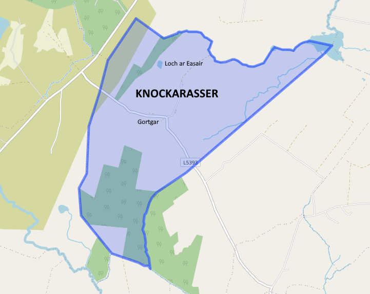
Knockarasser /Cnoc Ar Easair is a small farming Gaeltacht townland in the Taobh Garbh side of the Civil and Roman Catholic parish of Moycullen in County Galway. It is in Na Forbacha (Furbogh) Electoral Division. Tá Cnoc ar Easair i gceantar Scoile Leamhchoill. Its geographical coordinates are 53° 17′ 23″ North, 9° 13′ 48″ West. It is situated south of the parish, bounded on the north by Loughwell, on the east by Pollnaclogha, the south east by Lettergunnet of Barna parish, the south by Derryloughane of Spiddal parish and West by Knock. It is located 13km from Galway city via the L-5393 road, 4.2km from Furbo, 6.5km from Moycullen and 7.5km from Spiddal. The total area is 814 acres /1.27 square miles. Knockarasser is part of the Moycullen bogs Natural Heritage Area.
Topography and Features
Knockarasser is on an elevated site with panoramic views over Galway Bay, The Burren, Aran Islands, Twelve Bens, Galway City, Lough Corrib and large swathes of north and south Galway. The townland consists of two, southwest (NE-SW) oriented, drumlins of arable land, with a valley (Currach) in between and surrounded by blanket bog and forestry. Each householder was granted turbary rights at the edge of the townland. The highest point is 136 metres, known locally as the Tower (Tuar). In the approximate center of the townland is the ‘village of Gortgar’. (Short field).
View the Gortgar Drumlins site report from The Geological Heritage of County Galway.
There are five lakes in the townland:-
- Loch ar Easair/Lough Arasser
- Loch an Chip/Lough Kip
- An Loch Dubh/Lough Doo
- Loch idir Dhá Loch/Lough Eder
- Loch Leitir Gungaid/Lettergunnet Lough
A stream called An Sruthán Buí winds its way from Loch ar Easair into Lough Kip.
The origin of the name Cnoc ar Easair
O’Donovan’s field name books provide various spellings of this townland: Knockarasser, Cnoc a’ Rasaire/Racers Hill, Knockanasser (County Book), Knockeraser (County Map), Knockerasser (County Register 1820), Knockerasa (County Register 1832), Knockarassar (High constable for the Barony), Knockerasser (Printed Townland List from Major Browne), Knockarasser (Quit Rent Ledger), Knockarasser (Robt. Martin, Esq, Ross) Knockarasser (Sketch Map) Knockarassar (The Rev. E. French, P.P. Moycullen), Knockarasser (Thos. Martin. Esq. M.P.) and Knockarasser (Tithe Applotment Book). Paraic Breathnach and Máirtin O Cadhain, give the Irish version as Cnoc ar Eas Thoir meaning ‘The Hill of the Eastern Waterfall’. Logainm.ie shows the name as Cnoc ar Easair/Knockarasser. The Archival records of Logainm, show, Inter Alia, Easair means, straw and litter. Rev. Patrick S. Dinneen’s dictionary shows Easair/Asair, means litter for cattle, mountain vegetation and heather.
The most common view is that the townland took its name from the local lake, Lough Arasser. The lake is surrounded by Easair, e.g., mountain vegetation which was used for bedding and thatching houses. Locally this vegetation was also called sedge/seisc.
Land Ownership and Tenants
Down Survey 1656-1658
The Down Survey was a cadastral survey of Ireland carried out by English scientist William Petty in 1655 and 1656. The survey was apparently called the “Down Survey” by Petty because the results were set down in maps; ‘admeasurement down’ was used; it is referred to by that name in Petty’s will.
The Down Survey 1641 (pre-Cromwell) states that the owner was Sir Dominick Browne (Protestant). It is presumed that the O’Flaherty clan would have been the landlords before that date. The Down Survey Map 1670 (post-Cromwell) states that ownership of the lands had changed and now belonged to John Eyre (Protestant). It showed unprofitable land, 269 plantation acres, profitable land 38 acres and forfeited 38 plantation acres. John Eyre and his brother Edward were officers in Oliver Cromwell’s army. They were granted land in County Galway as payment for their services. Eyre Square, Galway City and Eyrecourt still reminds us of the Eyre family.
Tithe Applotment Books (1823-38)
Along the way, Richard Martin (Nimble Dick) of Dangan and Ballynahinch, acquired most of the land in Connemara including Knockarasser. According to the Tithe Applotment books, by 1828 the lessor was his great- great-grandson, Thomas Barnwall Martin, Ballynahinch. Thomas was the son of Humanity Dick Martin, who founded the Society for the Prevention of Cruelty to Animals.
The first available record of households is the Tithe Applotment Books. There was a Walter McDonagh (later Neds), James McDonagh (Mossy’s) and William McDonagh (Wats) resident in Knockarasser circa 1828 along with a land agent, John Hynes. It is fair to surmise that there was at least one McDonagh family there long before 1828. The original inhabitants lived in a clachan settlement of thatched houses in the Gortgar part of the townland.
Primary Valuation of Tenements (Griffith’s Valuation) (1853)
Sheet No 81,93
Griffith’s Valuation records show that the total annual valuation of rateable property in Knockarasser, based on a survey carried out by a Mr. Thomas Quinn on 22 September 1853, was £24(pounds) 15(shillings) 0d (pence). Made up of 4 households as follows:-
Bartholomew Kenny (Herds House and Lands) – £17(pounds) 0(shillings) 0d (pence)
Edmund McDonagh (Ned) – £3(pounds) 16(shillings) 0d (pence)
James McDonagh (Mossy’s) – £3(pounds) 16(shillings) 0d (pence)
John McDonagh (Wats) – £1(pounds) 18(shillings) 0d (pence)
There was 814 acres including 7 acres of water.
The 1841 and 1851 census show 8 houses – the extra households were obviously sharing land with the leaseholders.
Report of Landlord, Anthony O’Flahertie, by his agent Mr. Mons c1886
According to the report of Mr. Mons, there were 7 households in the townland circa 1886:-
1. Walter McDonagh Rent £2.5s.2d
2. William McDonagh Rent £2.5s.2d
3. Walter McDonagh £1.10s.2d
4. Pat McDonagh age 72/Peter McDonagh age 70 (for 3 lives) Rent £1.10s.2d
5. John McDonagh (Hse fallen) £1.10s.2d
6. Wat (Tom) McDonagh £2.5s.2d
7. John Kyne £2.5s.2d
Land Valuation Records (Available in Valuation Office, Abbey St. Dublin)
Thomas Martin died in 1847 during the Famine and Thomas’ only daughter and heir, Mary Laetita Martin, inherited a heavily encumbered estate. In 1849 the huge Martin Connemara estate of 196,540 acres was offered for sale. The London Law Life Assurance Society, to whom it was heavily mortgaged, purchased it in 1852, including the lands of Knockarasser.
The Land Valuation Records of 1862 to 1880 shows Bryan McSweeney as the lessor. According to the NUI Galway Landed Estates Database, Bryan McSweeney, with a London address was recorded as the owner of over 800 acres of land in County Galway. A Maria McSweeney (probably his widow) is shown as lessor from 1880 to 1903. From 1903 records show ‘In Fee’ which means that the householder had absolute ownership of his/her holding.
Land Valuation Records from 1862 show the arrival date of the following new families:
- c1862 -Richard Geraghty (Dan’s), Peter Conneely and Patrick McDonagh (Connors) and new land holders John Kyne and Sarah Reilly.
- c1876 1880 – Bartholomew Connor (in place of Patrick McDonagh), John Geraghty (Sean Johnny’s) ex John Kyne’s land, Peter Geraghty (Strachie) ex Sarah Reilly’s land and Michael Lee (Lee/Sullivan’s).
- c1895 Patrick Mulkerrin’s (Comers) and Matthew Higgins took up residence.
Census Information
Fr. Blake Census of Married men (1793–1813)
The Blake Census was the work of Francis Xavier Blake, the Parish priest in Moycullen between 1792 and 1825. The Census commences in 1793 and includes the name of every married man then residing in the parish as well as unmarried men having a separate dwelling whether bachelor or widower. Notations are made for those who are new to the parish, have moved, married, died, or becomes a widower.
Although the Blake Census does not separate out Knockarasser, its residents would have been shown under the townland area called Mountains. Blake’s show the following five McDonagh men in Knockarasser between 1793 and 1813: Wm McDonagh, Walt McDonagh, Wm McDonagh Wm, Peter McDonagh, and Walt McDonagh.
Census Records 1841 to 1891
The only records available for Knockarasser for the period between 1841 and 1891 are the summary details relating to housing, outhouses and population – individual returns for each household showing names etc. were all destroyed at the central records office Dublin in 1922:
| Year | Houses | Outbuildings | Males | Females | Total |
| 1841 | 8 | Not Recorded | 26 | 25 | 51 |
| 1851 | 8 | Not Recorded | 21 | 24 | 45 |
| 1861 | 6 | Not Recorded | 19 | 19 | 38 |
| 1871 | 10 | 4 | 27 | 24 | 51 |
| 1881 | 10 | 17 | 34 | 30 | 64 |
| 1891 | 11 | 24 | 37 | 29 | 66 |
1901 Census – Furbogh DED
There were 11 households in Knockarasser in 1901. There were 65 inhabitants, 38 were male and 27 were female. All occupants were farmers and Roman Catholics. The heads of households were:
John McDonagh (Ned’s)
*Mary McDonagh (Mossy’s)
John McDonagh (Wats)
Daniel Geraghty (Dan’s)
*William Conneely
Bartholomew Connor
John Geraghty (Johnny’s)
*Peter Geraghty (Strachie)
*Redmond Sullivan (Lee/Sullivan’s)
Patrick Mulkerrin’s (Comers)
*Matthew Higgins (Matt’s)
They all listed their occupation as farmer. Most adults could speak Irish and English and some of the adults could not read or write. All the dwellings had walls of stone, brick or concrete and a thatched roof. The households with an asterisk are no longer occupied. The enumerators responsible for the delivery and collection of the census forms in these local areas at the time would have carried out the chore by bicycle; the 1901 enumerator for Knockarasser was RIC Constable Denis Connor, based in Spiddal barracks.
1911 Census – Furbogh DED
There were 11 households in Knockarasser in 1911. There were 72 inhabitants, 40 were male and 32 were female. All occupants were farmers and Roman Catholics. The heads of households were:
Julia McDonagh (Ned’s)
*Mary McDonagh (Mossy’s)
John McDonagh (Wats)
Daniel Geraghty (Dan’s)
*Mary Conneely
Patrick Connor
Ellen Geraghty (Johnny’s)
*Peter Geraghty (Strachie)
*Michael Lee (Lee/Sullivan’s)
Patrick Mulkerrin’s (Comers)
*Mary Higgins (Matt’s)
They all listed their occupation as farmer. Most adults could speak Irish and English and some of the adults could not read or write. All the dwellings had walls of stone, brick or concrete and a thatched roof. The households with an asterisk are no longer occupied. All of the thatched cottages were gradually replaced by modern houses by the late 60’s. The 1911 census enumerator for Knockarasser was RIC Constable Samuel Hazlett of Spiddal barracks.
Households Update 2020
There are now (2020) 18 households in Knockarasser. Six households are occupied by the original families and the new builds are mainly occupied by their offspring. There are 42 inhabitants, 16 males and 26 females.
Summary data for the Griffith’s Valuation and the 1901 and 1911 Census are shown below:
| Townland Census Data | |||||
| Griffith 1855 | 1901 Census | 1911 Census | |||
| Head of Household | No. People | Head of Household | No. People | Head of Household | No. People |
| Bartholomew Kenny | Redmond Sullivan | 9 | Mary Conneely | 9 | |
| Edmond McDonagh | William Conneely | 8 | John McDonagh Watt | 6 | |
| James McDonagh | John McDonagh Ned | 4 | Mary McDonagh | 3 | |
| John McDonagh | Matthew Higgins | 3 | Michael Lee | 8 | |
| Mary McDonagh | 7 | Mary Higgins | 4 | ||
| John McDonagh Watt | 5 | Daniel Geraghty | 10 | ||
| Daniel Geraghty | 10 | Peter Geraghty | 2 | ||
| Peter Geraghty | 2 | Ellen Geraghty | 8 | ||
| John Geraghty | 6 | Patrick Connor | 7 | ||
| Bartley Connor | 5 | Patrick Mulkerrins | 6 | ||
| Patrick Mulkerrins | 6 | Julia McDonagh | 9 | ||
| Total | 65 | Total | 72 | ||
Origin of Original families
As noted in the earliest documented records (Blake Census) McDonagh’s have been resident in Knockarasser since at least the early 19th century. Prior to that they are thought to have come from the vicinity of Bealadangan, near Lettermore. In the latter half of the nineteenth century Peter Conneely arrived from Cappagh, Barna. He and the McDonagh’s were joined over time by Bartholomew Connor of Tamhnacha Bega, Moycullen; Michael Lee from Pollagh, Roscahill and his son in law Redmond Sullivan of Killagoola, Moycullen; Matthew Higgins, Doon, Roscahill; and Patrick Mulkerrins, Knocknacarra, Galway. The original home place of the Geraghty’s who appear in the 1901 Census is not known.
Life in Knockarasser
The landholders of Knockarasser leased their small holdings from various landlords until 1903, when they got absolute ownership of their holdings. The traditional way of life existed from the famine years well in to the 1960’s. Over this time rural life changed extraordinarily little. See Appendix 1.
Up until the 1960s they sowed potatoes, vegetables and corn and reared beef, pork, and poultry for the local markets. Housewives sold butter and eggs in Galway market and to local shopkeepers. Turf was also saved and sold by lorry load to farmers in the Oranmore area and by the bag or cartload to households in Galway City. Turf banks were also rented to Galway City people who cut and saved their own turf. Poitín was produced in the townland up to the 1950s. William Sullivan had a carpentry shop. Martin Geraghty built houses and had a lorry and block-making business. The men were employed on Council schemes during winter months to clean drains and keep up the roads. A man had to work a certain number of weeks each year to ‘earn stamps’ to qualify for Social Welfare.
There were poor prices for farm produce. Life in Ireland up to then was characterised by poor economic performance, high emigration, political instability, social conservatism and unfettered control of social policy and morals by the Roman Catholic Church. Most children finished their education in Loughwell primary school aged 14 and emigrated to England and the USA to work. Back then schools placed more emphasis on academic subjects and the catechism, than trades and life skills.
Whilst Knockarasser was in Moycullen parish, and Moycullen postal district, it was in the Spiddal General Practitioner (GP) and and Garda district. For that reason the Irish language was widely used when dealing with Spiddal matters. English is the most widely spoken language today. However, many Irish words are still used for field names and wildlife etc.
Fair days for Knockarasser people were held in Spiddal and in the Fair Green Galway for cattle, sheep and horses and a pig fair was held in the Fair Green, Moycullen. The butter and egg market were held beside St Nicholas’s Collegiate Church in Galway. Later the mart in Athenry replaced the fairs.
Luckily, life improved from the late 50s firstly due to the Whitaker Report of 1958 which ditched economic nationalism, brought women into the labour market, led slowly to the erosion of the Church-State relationship, and drove the reform of Irish law and society that created the capacity to have a private life. This was followed by the far-reaching change of Free second level education, which was introduced in September 1967. This is now widely seen as a milestone in Irish history. Farmers dole (1966) was also introduced around this time. The introduction of farm machinery reduced the need for manual labour, and the affordability of motor cars made personal transit faster and more comfortable than the horse that was replaced by both the car and the tractor. Ireland joined the Common Market (EU) in January 1973 which created new markets and reduced the reliance on the UK market.
Today’s generation of Knockarasser people can aspire to second level and third level education. Some residents are self-employed while others work in IT, trades, and services within their own county. The farm family members combine off-farm work with part-time farming, including saving enough turf for their own needs.
Saving the Turf
Knockarasser was blessed with numerous turf banks of quality black turf. Whilst the land provided subsistence farming, it was the bogs that provided extra income that helped families survive. Every household saved enough turf to heat their homes and cook their meals. Some farmers cut and saved extra turf to supply Galway City and the Oranmore area. Turf banks were also rented to city folk such as gardai and teachers. They mixed well with the locals and provided some employment for youths who were engaged to save their turf. Some farmers hired a Spailpín (casual labourer) during the summer months to cut turf. Saving turf was back breaking work but nevertheless it was enjoyable to work in the fresh air. The egg sandwiches and the bottle of tea always went down well.
Haymaking
June was the month for saving the hay. It was either mowed by the scythe or mowed by a contractor with a horse drawn machine. First you had to remove the dock-leaves and then turn it by hay fork several times to allow it dry out. When it was dry enough it was made in to haycocks. The changeable Irish weather meant it was always a race against time. If the weather was very broken the priest would announce at Sunday mass that it was ok to work in the meadow on a Sunday. We as youngsters hated this announcement as it meant forgoing playing football. After a few weeks a meitheal was organised to bring the hay into the haggard by horse and cart, and build it into a large haycock for winter storage. This was usually a fun day where the children frolicked in the hay and the men drank a few bottles of porter.
Pastimes
The past times of Knockarasser residents have been hunting and fishing, card playing, Ceilidhing, Storytelling, Dancing, Pitch and Toss, Weight Throwing, Athletics, Football, Handball, DIY and Crafts.
Attending mass on Sundays and holy days of obligation was both a spiritual and social occasion. Bank holidays were treated as normal working days. “When I was around 11 years old, I put on my Sunday clothes one bank holiday, my mother told me that bank holidays were only for people with a good job like my cousin, John Conneely, who work with Post & Telegraph”. Walter McDonagh
The highlight of the year was the House Stations held every Spring and Autumn. The Station area was Knock, Knockarasser and Knockalough and each household was expected to host the event every few years. The chosen house had to be painted and spruced up for the day. After confessions and mass, the man of the house joined the presiding priest and the altar boys for breakfast. The women and children were served a meal first, while the menfolk bade their time drinking bottles of porter or glasses of whiskey. Whiskey meant Poitín, and shop whiskey was called Parliament. Local lady, Peg Geraghty, always baked a chocolate cake for the stations which was the eagerly devoured by young and old.
Notable Knockarasser People
The McDonagh brothers, Michael, John, James, and Wat, were prominent members of Galway Harriers Athletic Club. Wat was also a poet. Their brother Martin (Mossy) was a noted jockey and a Seanchaí. Mossy lived alone in the last remaining thatched house until it collapsed in 1959. His brother Ned built a 2 bedroom chalet for him. Mossy lived beside the local well. His house was a meeting house for young and old. He had a great repertoire of songs and stories. Regrettably they were not recorded for prosperity. “Mossy gave me career advice when I told him that I was offered a job as a Post Office Clerk. He said the pen is lighter than the shovel”. Walter McDonagh
Cultural Sites and Places of Interest
Gortgar Village in the centre of the Townland, was the original “clachan” area where a few small, thatched cottages were concentrated in a cluster on the best land (the infields), which was surrounded by mountain or grazing land of inferior quality (the outfields).
The bogs of Knockarasser are home to a range of flora and fauna, including several varieties of moss as well as insect-eating plants and lichen etc. Peatlands in Ireland have traditionally been viewed as wastelands and sources of poverty.
The Tower (An Tuar) is the highest point in the area standing 136 metres has 360 degrees panoramic views of Galway Bay, The Burren, Aran Islands, Twelve Bens, Lough Corrib and beyond. Every Sunday and Public holiday young and old socialised on the site. On St John’s eve night of 23rd June, the neighbours gathered around a bonfire to celebrate the Feast Day of St John the Baptist. The Tower is home to a ‘Trig Pillar’, for Triangulation and the Mapping of Ireland.
Cnocán an Bhainne where women from Poll and Seanagurran took a break on the way to Galway market, to drink milk and eat bread. Mickey Coyne, a longtime resident of the townland, has suggested that they probably carried Poitín to the market.
Tul Aoibhinn is a lovely turbary area between Knockarasser and Derryloughane.
Spring Wells there are two a spring wells in the townland. Prior to running water those were the source of water for all households.
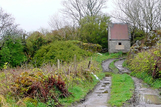
Farm Buildings There are two identical cement roofed buildings beside the vacant house of the Higgins family. Farm houses built in the 1930s/1940’s, included two small sheds, one for rearing pigs and one for rearing hens, see photo gallery.
Field Names and other local Names
Athaun , An Currach, Choc Bheag , Claisceana, Cnoc Beag, Cúl an Tower, Currach Beag, Curragh Mór , Drain Mhór, Fiodain Mór, The Fraochógs, Garden above the road, Garden of the Bog, Garden of the house , Garden of the Lake, Garden of the Tower, Garden of the Well, Garraí an Bhóthar, Garraí Balla, Garraí Beag, Garraí Bleine, Garraí Clai, Garrai Cnoc Bhig, Garraí Cruinneach, Garrai Gleannach, Garrai Gainne( sand), Garrai Mór, Garrai Na Heascainne ( eel), Garraí o eas, Garrai o’dheas, Garraí Pheadair, Garrai Sleibhe , Garraí Sruthan, Gort Dubh, Gort Leathan, Idir Dhá Mhuta, Leataobh an Bhóthair, Long Acre, Long Curach, Luachair Bheag Thiar ( rushes), Luachair Bheag Thoir, Muine Mór, Piosa Bheartla, Piosa Pháidin, Strachie, The Haggard, The Milking Garden, The Tower, Tuar Beag, Tula Bhig.
Take a Virtual Tour of Knockarasser (Courtesy of Google Maps)
References
- General information, Walter McDonagh and Maisie Lydon
- https://www.townlands.ie. & Google Maps Route Planner
- logainm.ie The Placenames Database of Ireland was created in collaboration with The Placenames Branch (Department of Culture, Heritage, and the Gaeltacht)
- Dinneen, Irish English Dictionary 1904 – explanation of the word Easair
- The Geological Heritage of County Galway = Report of Gortgar Drumlins
- Down Survey 1656-1658, Courtesy of Tomás O’Cadhain, Moycullen Heritage
- 1841-1891 Census figures www.histpop.org
- Census of Ireland 1901/1911 National Archives census.nationalarchives.ie/help/history
- Blake Census – moycullen.galwaycommunityheritage.org
- Valuation Office, Abbey Street Dublin
- Place names of Galway Galwaylibrary.ie/place
- O’Donovan’s field name books: Knockarasser
- Report of Landlord, Anthony O’Flahertie, by his agent Mr. Mons c1886 – courtesy of Conall Ó’Murchadha, An Spidéal
- TK Whitaker, Portrait of a Patriot – Anne Chambers
- The vegetation of southern connemara by Gertrude Connolly – Proceedings of the Royal Irish Academy. Section B: Biological, Geological, and Chemical Science
Vol. 39 (1929 – 1931), pp. 203-231
Comments about this page
Wow Walter, meas mór. Taighde an-chuimsitheach amach ‘s amach.
I’m a member of a group in Na Forbacha who have tasked ourselves with collecting and mapping ‘mion-logainmneacha ‘. They are, as you are aware, dissapearing fast. The group is newly-formed and the groups collection will not be available online until we have collected circa 100 placenames. If you’d like to give me a few placenames, in or near to Na Forbacha ,and associated seanchas and coordinates that would be very much appreciated.
Míle buíochas.
Colm
Add a comment about this page