Townlands of The Civil Parish of Moycullen
Here is a brief overview of the Townlands and some of the resources used when researching for the Townland Project. Visit our Townlands -Baile Fearann Page to discover more information about individual townlands.
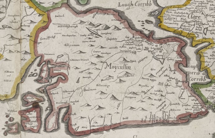
- Map of Moycullen
Geography of Moycullen
The Civil Parish of Moycullen stretches from Loch Corrib to the coast of Galway Bay. The smaller Roman Catholic Parish stretches from Loch Corrib to Knock and Knockarasser Townlands. There are seventy-six known townlands in the Civil Parish and fifty-nine townlands in the RC Parish.
What Is a Townland?
The Townland is the smallest and most ancient land division in Ireland, unique to the island and deeply embedded in its geography, history, and culture. There are over c61,000 townlands across the thirty-two counties of Ireland. Townlands range from an acre to thousands of acres.
Townlands in Irish Records
The Griffith’s Valuation (1847–1864), a detailed land valuation, relied on townlands for its structure. It cemented their use in property records, censuses, and tax collection, making them vital to local administration.
Cultural Importance Today
Townlands continue to be used in postal addresses, land ownership, electoral districts, and cultural identity. Rural people still strongly identify with their townland. The term Village is often used instead of Townland to this day. This may be due to translation from the Gaelic ‘Baile.’
Origins of Townland Names
Most townland names are derived from Irish Gaelic, reflecting local geography, history, families, or legends (e.g., “Drumlin” – ridge, “Bally” – town or homestead).
The Moycullen Heritage Townlands Project
How to Get Involved
Moycullen Heritage is currently documenting details of the Townlands in Moycullen Civil Parish. You are welcome to assist us with this project by sharing placenames, folklore, photos, and local stories. Just email us at [email protected].
Research Sources Used
- Townlands.ie The site provides a map, area, bordering Townlands and Sub-townlands – link to Moycullen Townlands on the site.
- Galway Library Placenames
- Place names in the townland of Moycullen This site includes placenames and their variant spellings, a derivation of the name, a description of the place, and its situation. (This site also has direct links to – Logainm, The Tithe Applotment Books, Griffith’s Valuation, 1901 Census and 1911 Census).
- Logainm The Logainm database shows: The official townland name in English and Irish, Phonetic pronunciation, Gaeltacht status, Archival records of research into the placename origin and Subunits such as lakes, rivers etcetera.
Historical Records
- The Down Survey (1656–1658) The English scientist William Petty conducted a cadastral survey of Ireland between 1655 and 1656. The results set down in maps hence it was called the ‘Down Survey.’ The Down Survey Map 1641 shows the landowners pre-Cromwell and The Down Survey Map 1670 shows the owner post-Cromwell.
- Tailte Éireann Valuation Records Land valuation records – Tailte Éireann Valuation Records, which show details of landlords and tenants from 1862 onwards, can be viewed by visiting the Valuation Office in the Irish Life Centre, Lower Abbey St., Dublin 1.
- The Blake Census of Moycullen (1793–1813) Francis Xavier Blake, Parish Priest of Moycullen (1783–1828), conducted his Census of Moycullen, listing the name of every married man and unmarried man having separate dwellings and whether they were bachelor or widower. He commenced the Census in 1793 and continued until circa 1822. The Census covered the years 1793 to 1813. Townlands included in the Census are shown under Census of Moycullen in the Moycullen Heritage Website. The Townlands on the Spiddal side of the parish are shown under ‘Mountains.’ The Blake Census of Moycullen is a lasting and unique contribution to local history.
- The Tithe Applotment Books (1823–1837) The Tithe Applotment Books are a valuable historical resource compiled between 1823 and 1837 in Ireland. They were created to assess the amount of tithe—a form of tax—that occupiers of agricultural land were required to pay to the Church of Ireland, the established church at the time. The records list the names of landholders in each townland, the amount of land they held, and the tithes they owed, making them an important genealogical and local history source. Although they do not include every individual (only those who held or worked the land), the Tithe Applotment Books provide a rare glimpse into rural Irish life before the Great Famine. They are the first National available record of households.
- Griffith’s Valuation (1847–1864) Griffith’s Valuation (Primary Valuation of Ireland) was conducted between 1847 and 1864 under the supervision of Richard Griffith. It was the first comprehensive valuation of land and buildings across Ireland and was primarily conducted for taxation purposes. The valuation lists the names of occupiers, lessors (landlords), the size and value of landholdings, and the type of property—making it an invaluable resource for genealogists and historians, especially since it predates the earliest complete Irish census records that survived. Griffith’s Valuation remains a cornerstone for tracing Irish ancestry and understanding land distribution in 19th-century Ireland.
- Irish Census (1821–1911) The British Government conducted a census of population every ten years from 1821 to 1911. Very few records before 1901 survived wars and fires. Fortunately, we have records of the number of households and population from 1841 to 1891. The 1901 and 1911 are available in 1901 and 1911 Censuses.
- Local Lore and Community Knowledge
- Folklore and Oral Traditions
- General information about the people, way of life, pastimes, etc., is provided by Moycullen Heritage, residents, and our publication – Maigh Cuilinn a Muintir – Cumann Staire Ruaidhrí Uí Fhlaitheartaigh.
- Photographic Archives – Photos are sourced from Maigh Cuilinn a Muintir, Geograph, and residents.
No Comments
Add a comment about this page