Knock/An Cnoc /The Hill
Knock/An Cnoc, is a small farming, Gaeltacht, townland in the RC parish of Moycullen in County Galway. It is located at 53° 17′ 4″ N, 9° 15′ 30″ W. It is situated south of the parish bounded on the north by Knockalough, Derryloughane East and Killough to the south, Knockarasser and Loughwell to the east, Shannagurraun and Truskaunnagappul to the west. It is located 15km from, Galway city, via the L-1355 road, 5.5km from Moycullen and 6.5km from Spiddal. Knock is part of the Moycullen bogs Natural Heritage Area. Knock is divided by the Moycullen to Spiddal Road into Knock East and Knock West.
Topography and Features
Knock is on an elevated site, with panoramic views over Galway Bay and The Burren. The townland consists of several small drumlins of arable land and surrounded by blanket bog. The total area is 956 acres. There are two lakes in the townland, An Loch Beag and An Loch Dubh/Lough Doo. It also borders Knockalough Lake. Abhainn an Chnoic/Knock River rises in Knockalough lake and winds its way to Galway Bay in Furbo. There are two streams- Sruthán na Teorann/Sruffaunnatoran
An Sruthán Beag/Sruffaunbeg. Cnocán an Droichid/Knockadrehid Bridge marks the border between Moycullen and An Spidéal. Knock is a very scenic area. From the hills you can see Lough Corrib, Galway Bay, the Clare hills and the Aran Islands and the hills to the west.
The Origin of the name An Cnoc
Knock is English of Cnoc which means Hill.
Land & Property Occupancy
Down Survey 1656-1658.
The Down Survey was a cadastral survey of Ireland carried out by William Petty, English scientist in 1655 and 1656.The survey was apparently called the “Down Survey” by Petty because the results were set down in maps; ‘admeasurement down’ was used; it is referred to by that name in Petty’s will.
The Down Survey Map 1641 (pre-Cromwell) states that the owners were, Daniell McMurrough O’Flaherty (Catholic).
It is presumed that the O’Flaherty clan would have been the landlords before that date. The Down Survey Map 1670 (post-Cromwell) states that ownership of the lands had changed and now belonged to Sir Thomas Meridith (Protestant). It showed unprofitable land 164 plantation acres, profitable land 165 acres and forfeited 165 plantation acres.
Tithe Applotment Books (1828)
There is no record for Knock in the Tithe Applotment Books (1828)
Land Valuation Records (Available in Valuation Office, Abbey St. Dublin)
The Valuations are only available at the Valuation Office in Dublin.
Census Records
Fr. Blake Census, 1793 – 1813
No data available as included in ‘Mountain’ area records. It is likely that a Bart Hehir and a Patt O’Donnell are from Knock.
Census 1841 to 1891
The only records available for Knock for the period between 1841 and 1891 are the total number of houses and population:
Year |
Houses |
Population |
1841 |
7 |
47 |
1851 |
6 |
38 |
1861 |
6 |
39 |
1871 |
8 |
36 |
1881 |
8 |
41 |
1891 |
6 |
46 |
The Griffith Valuation Records (1847 – 64)
The Griffith Valuation records show that the total Annual Valuation of Ratable Property in Knock in 1855 was £18 19 shillings 0d (pence). The landlord was Blake. The Household Heads were Mark Hare, Michael Murphy, William O’Donnell, Thomas O’Donnell, John O’Donnell, and Judith Kyne. There were 956 acres including 4 acres of water. Click here Griffith Valuation Knock, Moycullen.
1901 Census (Spiddal DED)
There were 6 households in Knock in 1901. There were 46 inhabitants. All occupants were farmers and Roman Catholics. The heads of households were Michael Hehir, Thomas O’Donnell, John O’Donnell, Patrick O’Donnell, Michael O’Donnell, and Martin O’Donnell.
They all listed their occupation as farmers, and all showed their religion as Roman Catholic. Most adults could speak Irish and English and some of the adults could not read or write. All the dwellings had walls of stone, brick or concrete and a thatched roof. The census enumerator was Constable Denis Connor, Spiddal.
1911 Census (Spiddal DED)
There were 6 households in Knock in 1911. There were 41 inhabitants. The heads of households were:
Michael Hehir, Martin O’Donnell, Thomas O’Donnell, John O’Donnell, Patrick O’Donnell, and Michael O’Donnell.
They all listed their occupation as farmer all were Roman Catholic. Interestingly the household of Martin O’Donnell listed a seamstress and a lacemaker. Local teacher Mary Duignan, from Cork, and her 3 children were lodgers in the same house. Most adults could speak Irish and English and some of the adults could not read or write. All the dwellings had walls of stone, brick or concrete and a thatched roof. The census enumerator was Constable Samuel Heylett, Spiddal.
Summary data for the Griffith’s Valuation and the 1901 and 1911 Census are shown below:
| Townland Census Data | |||||
| Griffith 1855 | 1901 Census | 1911 Census | |||
| Head of Household | Head of Household | Persons | Head of Household | Persons | |
| Mark Hare | Michael Hehir | 7 | Michael Hehir | 5 | |
| Michael Murphy | Thomas O’Donnell
|
10 | Martin O’Donnell | 12 | |
| William O’Donnell | John O’Donnell | 10 | Thomas O’Donnell
|
9 | |
| Thomas O’Donnell | Patrick O’Donnell | 8 | John O’Donnell | 8 | |
| John O’Donnell | Michael O’Donnell | 1 | Patrick O’Donnell | 6 | |
| Judith Kyne | Martin O’Donnell | 10 | Michael O’Donnell | 1 | |
| Total | 46 | Total | 41 | ||
Places of Cultural/Historical Interest

This restored cottage was the birthplace of Michael O’Hehir
Cnoc Suain– Family home of athlete, Michael Hehir, is now a retreat centre, run by husband and wife,
Dearbhla Standún and Charlie Troy. An old village has been restored on the site.
There was at one time a Big House in Knock which belonged to the landlord Duggan. The area was ravaged by the Great Famine and ruins of houses still serve as reminders of this sad event. It is said that there were stones to mark the many graves there.
The bogs, of Knock are home to a range of flora and fauna, including several varieties of moss as well as insect-eating plants and lichen etc. Peatlands in Ireland have traditionally been viewed as wastelands and sources of poverty.
Famine Grave
GA081-015
Class: Barrow – unclassified
Townland: AN CNOC (TC An Spidéal)
Scheduled for inclusion in the next revision of the RMP: Yes
Description: On a ridge summit surrounded by bogland. A subcircular platform (NNE-SSW 14.5m, WNW-ESE 11.5m), in fair condition, defined by a scarp. The interior is slightly dished and a gap at E could be original. A barrow.
The above description is derived from the published ‘Archaeological Inventory of County Galway Vol. I – West Galway’. Compiled by Paul Gosling (Dublin: Stationery Office, 1993).
Date of upload: 05 August 2010
Google – Historic Environment Viewer
Field and other local names:
Ros Choill Cnoc Raw,
Cnoc na gCaorán Dubh,
Cnoc an Gharráin,
An Cnoc Garbh,
The Himalayas
Origin of Original families
People of Knock
The landholders of Knock leased their small holding from various landlords until 1903, when they got absolute ownership of their holdings. The traditional way of life existed from the famine years well into the 1960’s. Over this time rural life changed extraordinarily little.
Up until the 1960s they sowed potatoes, vegetables and corn and reared beef, pork, and poultry for the local markets. Housewives sold butter and eggs in Galway market and to local shopkeepers. Turf was also saved and sold by lorry load to famers in the Oranmore area and by the bag or cartload to households in Galway City. Turf banks were also rented to Galway City people who cut and saved their own turf. Poitín was produced in the townland up to the 1950s.The men were employed on Council schemes during winter months to clean drains and in the upkeep of roads. A man had to work a certain number of weeks each year to ‘earn stamps’ to qualify for Social Welfare.
There were poor prices for farm produce. Life in Ireland up to then was characterised by poor economic performance, high emigration, political instability, social conservatism and unfettered control of social policy and morals by the Catholic Church. Most children finished their education in Loughwell primary school aged 14 and emigrated to England and the USA to work. Back then schools placed more emphasis on academic subjects and catechism, than trades and life skills.
Irish was the spoken language to the 1960’s when the area became bi-lingual.
Fair days for Knock people were held in Spiddal and in the Fair Green Galway for cattle, sheep and horses and a pig fair was held in the Fair Green, Moycullen. The butter and egg market were held beside the St Nicholas’s Church in Galway. The original families were no longer in the townland by the 1970’s.
Notable Knock People
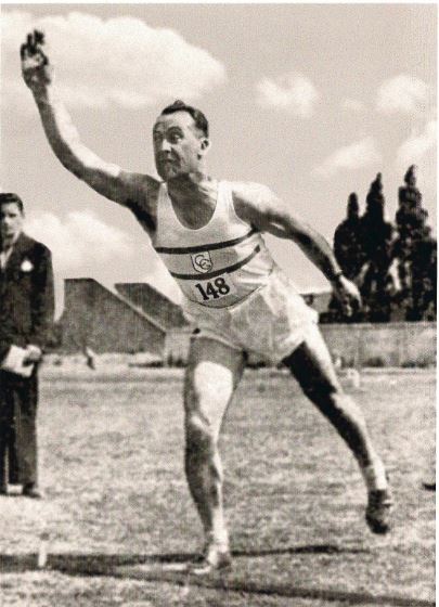
Michael O’Hehir circa 1952
Michael Hehir was born in 1918, in the house now known as ‘Cnoc Suain’. Michael was the holder of the world record of 29’2” throwing the 56lb, without follow, as well as 13 All Ireland gold medals. Dearbhla Standún of Cnoc Suain, is a well-known musician.
Pastimes
The past times of Knock residents have been hunting and fishing, card playing, Ceilidhing, Storytelling, Dancing, Pitch and Toss, Weight Throwing, Athletics, Football, Handball, DIY and Crafts.
Attending Sunday mass was both a spiritual and social occasion. The highlight of the year was the House Stations held every Spring and Autumn. The Station area was Knock, Knockarasser and Knockalough and each household was expected to host the event every few years. The chosen house had to be painted and spruced up for the day. After confessions and mass, the man of the house joined the presiding priest and the altar boys for breakfast. The women and children were served a meal first while the menfolk bided their time drinking bottles of porter or glasses of whiskey. Whiskey meant Poitín and shop whiskey was called Parliament. Local lady, Peg Geraghty, always baked a chocolate cake for the stations which was eagerly devoured by young and old.
References
- General information, Walter McDonagh
- logainm.ie The Placenames Database of Ireland was created in collaboration with The Placenames Branch (Department of Culture, Heritage, and the Gaeltacht)
- Irish Townlands
- Maigh Cuilinn a Muintir, Cumann Staire Ruaidhrí Uí Fhlaitheartaigh
- Maigh Cuilinn a Táisc agus a Tuairisc – Pádraic Breathnach
- The Geological Heritage of County Galway = Report of Gortgar Drumlins
- Down Survey 1656-1658, Courtesy of Tomás O’Cadhain, Moycullen Heritage
- Census of Ireland 1901/1911 National Archives census.nationalarchives.ie/help/history
- Blake Census – moycullen.galwaycommunityheritage.org
- Valuation Office, Abbey Street Dublin
- Place names of Galway Galwaylibrary.ie/place, O’Donovan’s field name books: Knockarasser
- ie
- ie
- Historic Environment Viewer- National Monument Service
- Field Names, Walter McDonagh, and Maisie Lydon
No Comments
Add a comment about this page