Killagoola


Killagoola townland has been for generations an Irish-speaking, farming community. The tradition of hard work and self-sufficiency in Killagoola village went together with a focus on literacy and education from the days of “ Garraí na Scolaire” the Hedge school in the townland in penal times. Today the community of long established and recent residents have access to more varied employment in the much-developed Moycullen village and Galway city which is 11 km to the southeast. Located in the parish of Moycullen in County Galway, its geographical coordinates are 53° 19′ 1″ N, 9° 11′ 19″ W . It is situated south of Moycullen village and is bounded by the townlands of Kylebroughlan on the north, Clydagh, Tooreeny and Poulnaclogha on the south, Gortyloughlin and Keagh on the west and Uggool on the east.
Topography and Features
Killagoola village lies in the valley of Cru Hill. There are scenic views from this elevation of Connemara to the north and Lough Corrib and Galway city to the south. The highest point of Cru Hill (also known as Crew and Cruckillagoola/ Killagoola Hill) is at elevation 471 feet located on the north side of the townland near its boundary with Kylebroughlan. The slopes incorporate one third of the townland descending to the farms of Killagoola and the heath along the Lough Kip River (also known as the Killagoola River). As described in O’Donovan’s Field Name Books (1839) “the greatest portion of this townland is a moorish, heathy, wet pasturage, the other portion is in cultivation.” (1)
The total area of Killagoola is 1.38 square miles/883 acres. Much of the southern boundary is the Lough Kip River, which flows into Ballyquirke Lake. Two streams rise from Cru Hill and flow into the Lough Kip River in Killagoola. O’Donovan notes these as Sruffaunagarra (Sruthán Garbh, which may mean “rough water”) and Sruffaunboy (Sruthán Buí, meaning “stream of yellow water” and this colouration continues today due to minerals in the water.) The Ordnance Survey of 1840 noted two small settlements in the townland: Killagoola and the smaller Ballybanny to the west. The place name Ballybanny is no longer in use, instead the place name Baile Thiar or West Village, may be used for this area of the townland.
Writer and folklorist, Padraic Breathnach, described Killagoola as being divided into four parts: “Baile Láir (Middle Village), Baile Thiar (West Village), Sráid Tí Mhóir (Street of the Big House) and Radharc na Mona (Mount View).”(2) The middle area, Baile Láir is now known as the “village” of Killagoola. Sráid Tí Mhóir to the northeastern side of the townland was named in reference to the large house of the O’Flaherty land agent. Radharc na Mona (Mount View) is to the southeast.
Origin of the Name Cill Ogúla/ Cill Eaguala /Cillaghuala.
Cill Ogúla is advised as the Irish form of the name Killagoola by Ordnance Survey Ireland 2020 and Logainm. (3) Ogúl is understood to mean “a junction, connecting piece of land” though this is not certain and Cill to mean church.
However, many local and other sources including John O’Donovan in the Field Name Books 1839 note the place name Killagoola, is from Cill a’ Ghuala, “Church on the shoulder of the hill.” (1) This monastic church is now in ruins. P. Breathnach writes: “ Cill a Guala is how the name of this townland is said… and there are people who would say that the original name means ‘church on the shoulder of a hill.” He also notes Killagoola, Cill Eaguala means the church of Uggool and thus surmises they were originally one village. (2) Bartley Faherty, born in Killagoola, wrote in his memoir The View From Cru Hill “The village of Killagoola got its name I was told by elders of the village because of an old church which had a cure of the eyes.” (4) However, John Reilly landowner in Killagoola, maintained in a 1990 interview in “Moycullen Matters” magazine that the townland name Cill Eagúla was derived from Cill Iarghualta meaning remote church. (5) Killagollagh, Killogulla, Killagoolagh, Cill a Guala, and Cill Uguala are other variations of the name. (1)(6)
Land Ownership and Tenants
Down Survey 1656-1658.
The Down Survey was the first detailed land survey on a national scale. The information recorded in regard to Killagoola on the Trinity College, Down Survey website appears to be generic stating this is “glebe” or church land. Research of source material for the Down survey is transcribed here from “Killagoola, a history of a west Galway Townland” in which the Book of Survey and Distribution 1636-1703 is referenced. (6) This records the names of proprietors who forfeited their land in 1641 and the names of those to whom this land was granted.
This finds the first landlords recorded for Killagoola are the Martins.
Book of Survey and Distribution: Barony of Muckullin
Rahon Parish (sic) : Proprietor Anno: 1641 Robert Martin
With description “Killagola 3 car of heathy mountain 1/10th pt pasturable cont. Arrable and heathy pasture wth a little Mill. A parcell of heath 1/10th pt past in controversy wth Killbrolahan cont. Another parcell of heath 1/10th pasturable cont.”
Number of Acres unproffitable is 227 and Numbr. of Acres Profittable (sic) is 159.
It is noted then to whom the land has been transferred: Edmund Martin and Richard Martin who are landowners of Killagoola by the end of the 1600s.
These Martins were to become known as the Martins of Ross as they were established beside Ross Lake in Moycullen, from the late 16th Century where they purchased land from the Connemara O’Flaherty clan. The Martins had property forfeited in Galway City at the time of the Cromwellian invasions (1640s) but records note that land was granted to them in the barony of Moycullen in 1677. (6)
Units of land at this time in Connacht were called cartrons (abbreviated as “car” in the early records). A cartron was 30 acres in size. Land was divided into quarters and a quarter was four cartrons. Notably there was a difference between the size of an Irish acre and a plantation acre, and a plantation acre could widely vary in size from ten to thirty acres. (7)
Tithe Applotment Books (1828)
The Tithe Applotment books were recorded to determine the amount which occupiers of agricultural holdings over one acre should pay as a tax on agricultural produce to the Church of Ireland. The majority of the population at this time lived on land rented from landlords and the occupiers would have been the tenants of the landlords.
By 1828 two landlords are recorded for Killagoola, Anthony O’ Flaherty and Edward Martin.
The Tithe Applotment Book of 1828 show Anthony O’Flaherty, Esquire as landlord in Killagoola and lists the occupiers as: Chas Lydden, John Haneen, Patt Walsh, and Marcus Malony
Edward Martin is the second Landlord recorded in Killagoola in 1828 with those listed as occupiers of land “Edm (may be O’) Connor, Tim Sullivan, Jno Regan, John Connor and Patk Faherty & co.” In the National archives table Wm Cortelle (may be Costello) Martin Mey (this may be Fahy or Riley) and Thos Walsh are also listed as occupiers of land in the Tithe Applotment Books (1828) for Killagoola.
The Martins seat was Ross Castle, which at the time of Griffith’s Valuation (1847-1864) was valued at £20. Well-regarded by their tenants, they lost their lands after the famine when rents could not be paid. (6)
Anthony O’Flaherty (1800-1866) lived at Knockbane House, Moycullen and was of the Renvyle branch of the O’Flahertys. His father, also Anthony, had purchased Killagoola in 1803 as part of more than 2000 acres of land spread across eleven townlands in Moycullen. Anthony O’Flaherty, Esq. was locally prominent and popular; he was Chairman of the Galway Workhouse Union and Member of Parliament for Galway as a Repealer and Whig from the years 1847 to 1857.
The Griffith Valuation Records (1847 –1864)
The Primary Valuation of Ireland also known as Griffith’s Valuation was carried out between 1847 and 1864 calculating the value of each land holding to determine liability to pay a tax for the support of the poor and destitute.ge
At the time of Griffith’s Valuation, the Martins were no longer recorded as landlords or part landlords of Killagoola, leaving Anthony O’Flaherty as the sole landlord.
The Griffith Valuation records show that the total Annual Valuation of Ratable Property owned by O’Flaherty in Killagoola was £114. At the eastern end of Killagoola in the area known as Sraid Ti Mhoir, there were six occupiers, Catherine Noon, Thomas Lydon, Peter Mullowney, Bridget Walsh, Patrick Lydon and Thomas Connor. At the other end of the townland around Ballybanny or Baile Thiar were another 7 occupiers: the Hallorans (Patrick and Andrew, sons of Ulick Halloran) and Patrick Halloran, son of Owen Halloran; Patrick Faherty, Martin Bane, John Sullivan and John Sullivan, Jr. The largest number of occupiers were in the vicinity of Baile Lair also known as Killagoola village: John Noon, Bartholomew Reilly, Michael Madden, Martin Larner, Thomas Reilly, Michael Reilly, Patrick Reilly, Patrick Toole, Michael Halloran, Cecilia Connor and John O’Grady.
Census Information
Blake Census of Married Men, 1793 – 1813
The Blake Census was the work of Francis Xavier Blake, the parish priest in Moycullen between 1792 and 1825. This is unique to Moycullen and to note it was recorded before the Tithe Applotment Books (1828) and The Griffith Valuation Records (1847 –1864). At this time many families were moving between townlands and surnames vary greatly from those which are recorded in Killagoola from the Tithe Applotment Books onwards, where the same family names are seen in subsequent surveys and censuses.
The Census commences in 1793 and includes the name of every married man then residing in the parish as well as unmarried men having a separate dwelling whether bachelor or widower. Notations are made for those who are new to the parish, have moved, married, died or becomes a widower.
The Blake Census counted 35 men in Killagoola during the census period: Morgan Ahern, (new resident as of 1811), Mark Bane, John Cannavan (married in 1794, widowed in 1801 and remarried in 1802), Mark Clancy, (married in 1799), Roger Conneely, (married in 1812), Martin Connor, (married in 1798 and died in 1807), Mathias Connor,(married in 1808), William Divilly (widowed in 1800), James Donohoe (moved from Moycullen parish in 1796, Thomas Connor (married 1794), John Gibbons, (married 1797 and moved from Moycullen in 1800), Myles Gibbons (died in 1797), Andrew Halloran (died in 1811), Michael Halloran, Owen Hogan (died in 1797), Martin Hurny (married in 1812), Patt Hurny Junior, (married in 1800), Mick Hynes, (new resident as of 1797), John Joyce, John McDonogh (married in 1802 and moved from Moycullen in 1806), Michael MacHugo (married in 1807), Thomas Moylan, (died 1804), William Mulloy, Michael Murphy Junior (married in 1795, widowed in 1805 and remarried in 1807), John Reilly, Pat Reilly (new resident in 1812), Thomas Reilly (married in 1811), Bart Russell, John Tiernan, Andrew Toole (married in 1803), James Toole (married in 1807 and died in 1809), Thomas Walsh and three other Walshes who arrived in 1798: Martin, Patt Senior (died 1805) and Patt Junior (married in 1798).
Census Records 1841 to 1891
The only records available for Killagoola for the period from 1841 to 1891 are the total number of houses and population:
| Year | Houses | Population |
| 1841 | 40 | 210 |
| 1851 | 30 | 205 |
| 1861 | 30 | 183 |
| 1871 | 30 | 164 |
| 1881 | 30 | 210 |
| 1891 | 31 | 191 |
National Census of Ireland 1901 & 1911
The 1901 and 1911 censuses are the only surviving full censuses of Ireland open to the public. Previous censuses from 1821-51 were, apart from a few surviving documents, destroyed in 1922 in the fire at the Public Record Office at the beginning of the Civil War.
Census of 1901
In the 1901 Census of Ireland, Killagoola townland is recorded as having 32 households and a population of 157 people in total with 73 males and 84 females. All are recorded as Catholics, and all spoke Irish. The majority were bilingual but 11 spoke Irish only. The 1901 census documents that the occupation of the majority of the 32 households was listed as “Farmers” or as “Farmer’s sons or daughters.” 29 of the 32 households listed the primary occupation as Farming. The other occupations documented are 1 wheelwright, 1 carpenter, 2 wool carders, 1 housekeeper, 1 servant, 1 general labourer.
1901 Census for Killagoola: Names of heads of households (and if married and spouse still living, the name of spouse is also given here.)
Anne Lydon, Rebecca Toole, Margaret Folan, John & Kate Connor, Mary Connor, James Bartly & Kate Reilly, Margaret Moloney, Bridget Lydon, Patrick & Honor Noone, Sarah Noone, John Bartly & Winafred Reilly, Michael Madden, James & Bridget Madden, Patrick & Sarah Reilly, Michael & Kate Reilly, John Michl Rielly, Patrick & Ellen Keady, John Tom & Honor Reilly, John Faherty, Lawrence & Mary Faherty, Margt Holloran, Joseph & Bridget Toole, Anne Devany, John & Mary Sullivan, Matthew Faherty, John Bane, Catherine Sullivan, Redmond Sullivan, James & Honor Holloran, Matthias & Anne Keady, John & Maggie Keady, Cecily Lydon. Spelling of names is as recorded on Census 1901/11 website. (6)
Census of 1911
The records of the 1911 census of Ireland for Killagoola townland show there were 32 households and a population of 133 people in total, 66 males and 67 females. All are documented as Catholics in 1911 as in 1901 and all speak Irish. The majority are bilingual in English and 6 speak only Irish. In terms of occupation all are recorded as farmers except 2 carpenters and a Sclábhaíde (farm labourer.)
1911 Census for Killagoola: Names of heads of households (and if married and spouse still living, the name of spouse is also given here.)
Anna Ní Loideáin/O’Loideáin, Sibéal O’Tuathail, Cáit Ní Chonnchubhair
/O’ Conncubhair, Máire Ní Chonnchubhair/ Ua Connchubhair, Seamus & Cáit O’ Raghallaigh, Seágan & Mairgheadh O’Conaire, Brighid Ní Loidean/
O’ Loideán, Pádhraic O’Maoldhomhnaigh, Patrick & Honor Noone, Sarah Noone, Úna Ní Raghallaigh, Riocard & Sadhbh Breathnach, Brighid Ní Maduighin/O’ Maduighin, James Madden, Michael & Kate Reilly, Patrick & Sarah Reilly, John Mich. Reilly, Ellen Keady, Michael Reilly, Patrick Faherty Mary Faherty, Margt Holloran, Patrick Toole, Anna Ní Dhubháin/ O’Dubháin
John & Mary Sullivan, Mathew & Brigid Faherty, Catherine Sullivon, Celia Lydon, John Bane, Bridget Sullivan, Seághan & Mairghead Ua Céide/
Ó’Céide/Ní Chéide, Maitiu & Anna Ua Céide/Ó’Céide/Ní Chéide, James & Honor Holloran.
Spelling of names is as recorded on Census 1901/11 website. In 1911 the Gaelic League encouraged filling out the census in Irish and in Killagoola over one third of the households did so. (6)
Summary data for the Griffith’s Valuation and the 1901 and 1911 Census is shown below as recorded in “Maigh Cuilinn A Muintir” Cumann Staire Mhaigh Cuilinn published 2008.
Noting corrections to this list as follow : In 1901 there were 32 households and the population on analysing the individual census return forms of 1901and noting enumerator’s total is 157 rather than 162 recorded on this list. In 1901 spelling is Margaret Moloney, and John Tom Reilly should have 5 rather than 15 in the household. Cecily Lydon is missing from list. In 1911 Pádhraic O’Maoldhomhnaigh is translated as Patrick Molloy and this should be Patrick Muldowney.
| Townland Census Data | |||||
| Griffith 1855 | 1901 Census | 1911 Census | |||
| Head of Household | No. People | Head of Household | No. People | Head of Household | No. People |
| Catherine Noon | John Bane | 1 | John Bane | 1 | |
| Thomas Lydon | John Connor | 7 | Kate Connor | 7 | |
| Peter Mullowney | Mary Connor | 3 | Mary Connor | 2 | |
| Bridget Walsh | Anne Devany | 4 | Anne Devaney | 3 | |
| Patrick Lydon | John Faherty | 7 | Patrick Faherty | 3 | |
| Thomas Connor | Lawrence Faherty | 7 | Mary Faherty | 5 | |
| John Noon | Matthew Faherty | 3 | Matt Faherty | 4 | |
| Bartholomew Reilly | Margaret Folan | 1 | Margaret Halloran | 2 | |
| Michael Madden | Margaret Halloran | 4 | James Halloran | 11 | |
| Martin Larner | James Halloran | 7 | Ellen Keady | 3 | |
| Thomas Reilly | Patrick Keady | 4 | John Keady | 10 | |
| Michael Reilly | Matthias Keady | 10 | Matt Keady | 11 | |
| Patrick Reilly | John Keady | 11 | Anne Lydon | 3 | |
| Patrick Toole | Anne Lydon | 4 | Bridget Lydon | 4 | |
| Michael Halloran | Bridget Lydon | 7 | Celia Lydon | 2 | |
| Cecilia Connor | Michael Madden | 4 | Bridget Madden | 2 | |
| John O Grady | James Madden | 5 | James Madden | 4 | |
| Patrick Halloran (Urick) | Margaret Molloney | 2 | Patrick Molloy | 1 | |
| Andrew Halloran | Patrick Noone | 6 | Patrick Noone | 5 | |
| Patrick Halloran (Owen) | Sarah Noone | 8 | Sarah Noone | 6 | |
| Patrick Faherty | Patrick Reilly | 4 | James Reilly | 5 | |
| Martin Bane | Michael Reilly | 2 | Winifred Reilly | 8 | |
| John Sullivan | John Reilly Bartley | 3 | Michael Reilly | 2 | |
| John Sullivan Jnr | James Reilly Bartley | 5 | Patrick Reilly | 4 | |
| John Reilly Mick | 5 | John Reilly | 4 | ||
| John Reilly Tom | 15 | Mick Reilly | 2 | ||
| John Sullivan | 6 | John Sullivan | 6 | ||
| Catherine Sullivan | 5 | Catherine Sullivan | 3 | ||
| Redmond Sullivan | 1 | Bridget Sullivan | 1 | ||
| Rebecca Toole | 7 | Rebecca Toole | 6 | ||
| Joseph Toole | 4 | Patrick Toole | 3 | ||
| Total | 162 | Total | 133 | ||
Housing in 1901 and 1911 Killagoola
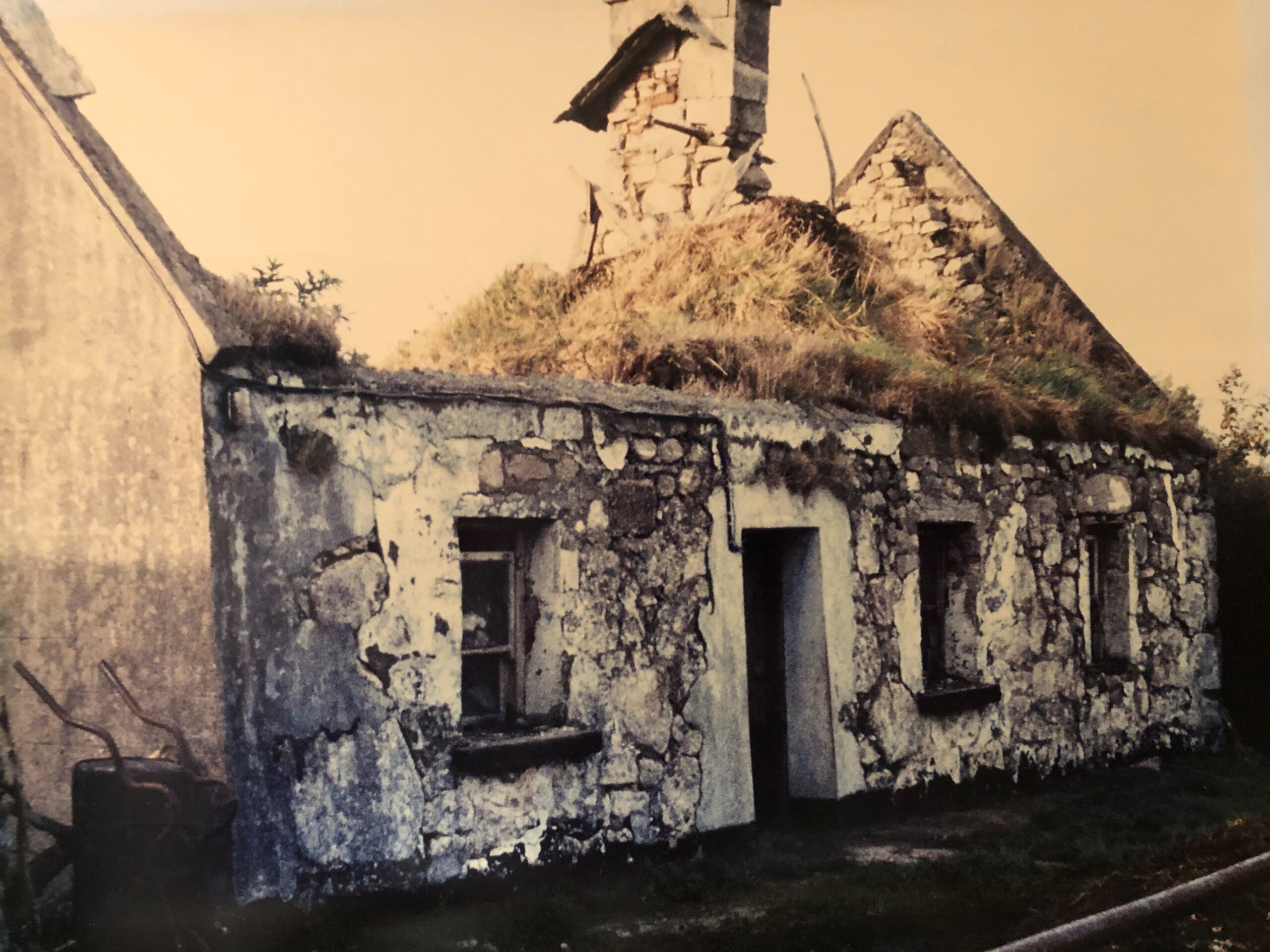
In 1901 there were 32 homes in the townland. All were built from stone and thatch with 17 classified as 2nd class. “ Second class houses were classified as having up to 5 or 6 rooms and up to 4 windows to the front of the house. In Killagoola almost all houses had 3 windows in the front of the house. To be classified as first class a house would need to have slates or tiles on the roof. Thirteen houses had 1-2 rooms with windows in the front of the house and 2 had just one room.
In 1911 there were 31 homes with 19 having up to 5 or 6 rooms suggesting that some may have extended the size of their homes during the first decade of the century. Ten houses had 1-2 rooms and windows in the front of the house and 2 had just one room.
Indicative of the type of farming practiced in Killagoola, in 1901 there were 87 outbuildings recorded in total including 11 stables, 32 cow houses and 25 piggeries. In 1911 there were 15 stables, 28 cow houses, 20 piggeries and 5 fowl houses.
People of Killagoola
Killagoola historically was one of the most populated townlands in Moycullen. Most of the families were interconnected through marriage over the years. Even at the time of Blake’s Census at the turn of the 19th century 37 men were listed as resident in the townland but there were only 26 surnames. At this time many families continued to move between townlands. By the 19th Century the Tithe applotment books record the surnames associated with Killagoola through subsequent surveys and census to the present day.
Many families in rural areas had the same surnames and to distinguish these families the Christian name of the father or mother was included in the name, such as John Tom or John Bartly as seen in the census. One family of Walshs in Killagoola were known as the “Ricks” as the father was Richard Walsh (born in 1876.) Names were also connected with occupation and the Maddens were known far and wide by their occupation as the “Millers”.
For generations the people of Killagoola were farmers engaged in mixed farming with sheep, pigs and dairy. They were subsistence farmers who grew their own food on the farm, (potatoes and vegetables), kept cows for milk and butter, and a pig and hens for meat and eggs and the rest was sold at market . Pigs went to market down Uggool boreen to the pound in the Village and sheep were dipped in the Lough Kip River on the way to the market and this practice took place until the 1970s.
Killagoola was a close-knit community where working together was common. Meitheals took place with neighbours helping each other with tasks such as corn threshing and making reeks of hay for winter storage.
Killagoola homes were heated by turf saved from bogs in nearby Caoch (Keeagh) townland. There, most Killagoola families had turbary rights to cut, and save turf which included spreading and taking turf home. Any extra turf was sold on.
Madden’s Mill in Killagoola served townlands across Moycullen who took their wheat, corn, barley and oats to the mill by horse or donkey and cart.
Other occupations in the townland noted in the 1901 and 1911 census were carpenter and wheelright. Women’s occupations included spinning which was an important skill at the time in order to make clothes from local materials. A related occupation for women was carding which was the process of cleaning and making wool ready for spinning and knitting. Killagoola townland was noted also for poitín making where the local grain such as barley or oats was used in the process.
John Sullivan was the wheelwright in Killagoola in the 1940s and 1950s who made farm equipment for the people of Moycullen, most importantly the horse cart which did most of the hauling of goods, manure and hay up until the 1950s. His craftsmanship was described as “a great piece of carpentry and the spoked wheels were intricate work.” (4)
Sullivan’s carts were undoubtedly used in what locals remember as “chariot races” in Killagoola. These races of donkey and horse driven carts through the boreens of Killagoola were a precursor to more exciting racing to come. During the late 1970s the narrow roads of Killagoola were part of the course for the Galway International Rally, the first major rally event ever to occur in Ireland.
Pastimes
Neighbours visited each other, often every evening, chatting & telling stories, some of them ghost stories about the Síog or fairyworld. By the 1970s the visiting and storytelling custom was dying out. Electrification which came to the townland in the 1960s and television were factors.
In the 1950s the Walshs were noted for having a radio and the neighbours went there to listen to matches and the All-Ireland Hurling and Football finals.
Emigration
Due to difficult economic circumstances many generations of Killagoola people emigrated to America, England and other parts of the world where their many descendants live today such as John Walsh (1907-1992) the son of Richard and Sarah Walsh of Killagoola.
John attended school in Moycullen and then worked as a farmer. At age 22 he emigrated to the USA, sailing from Galway to Boston on board the SS Cleveland in 1929. Leaving home, he would have been aware that he might never return, and he did not do so for 52 years. Moving to New York as the Wall Street Crash was taking place, he settled there, married and had six children most of whom attended university. John’s son also called John, became Head of Bus Transit for New York City. John and his family maintained a lifelong connection with Killagoola.
In the 1901 and 1911 census, the high levels of literacy can be seen in Killagoola. There was always close contact between the emigrants and their families who looked forward to postman John Audley bringing regular letters or parcels from America or England with news of their son or daughters’ new life together with money, clothes and presents.
Among the Killagoola families, Hallorans and Sullivans from Killagoola along with Cookes from nearby Uggool were early emigrants to Washington D.C. There, with other Moycullen people, they formed the nucleus of an Irish community in the Foggy Bottom district of America’s capital city.
There is still some emigration but for today’s younger Killagoola generation with the training and educational opportunities available there would be a great deal more choice of employment at home or abroad than there was in the past.
Today’s generation of Killagoola people would have extensive training and educational and employment options. Many would be third level students in NUI Galway, GMIT or other colleges. Others are employed in retail and business, and multinational companies in Galway city, IT, the health services, arts, law, civil service, engineering, teaching and lecturing. They are skilled tradesmen, managers, hoteliers, photographers, tree surgeons, & architects while also bringing up their families, and many still farming the land in the townland.
Notable Killagoola People
William Patrick Madden (1831-1895) was born in Killagoola and emigrated to the United States where, after serving in the United States Army, he founded St. Bridget, an Irish farming community in Kansas. He later became the first Probate Judge of Marshall County, Kansas.
Places of Cultural and Historical Interest
The self-sufficiency of Killagoola townland over the centuries was noted by John Reilly, born in the 1930s, who spent his life on the family farm in Killagoola. When interviewed by Moycullen Matters magazine in the 1990s, he said Killagoola had its own church, a blacksmith and a school, a flour mill and flax mill. A farmer brought wheat to Maddens Mill and returned home with a sack of caiscín (wholemeal flour.) (5) (6) The flour mill was in the eastern end of the townland beside Lough Kip River and was in use until the 1950s when it was demolished during the river drainage.
Cru Hill
From Cru Hill (elevation 471 feet) there are unobstructed views of Lough Corrib, Galway Bay, and Killannin, the Twelve Pins and in the other direction the hills of County Clare. The location of Killagoola in the sheltered valley of Cru Hill may have been protective during the Famine, as it is said locally that the population numbers of the townland were not affected like other areas. (6) In the past, day dances took place on the top of Cru hill with the blind piper Stiofán Ó Rúain of Shantalla playing tunes with bonfires lit. (2)
Teampall Einne (St. Enda’s Church)
Killagoola meaning “Church on the shoulder of the hill, refers to Teampall Einne, St Enda’s church, now in ruins. It is believed Teampall Einne was part of a monastic settlement built by followers of St Enda who founded the first monastery in Ireland on the Aran Islands. (8) Folklore recalls this connection as P. Breathnach writes “ Ag tíocht as Árainn a bhí Naomh Éanna nuair a thóg sé an teampall seo. Bheannaigh Naomh Éanna an áit agus dúirt go mbeadh flúirse éisc sna lochanna.” “Saint Enda was coming from the Aran Islands when he built this church & blessed the place so there would be a plentiful supply of fish in the lakes.” (2) Further recollections from J. Reilly were that the last mass took place in Teampall Einne 1000 years ago. (6)
From the Archaeological Inventory of County Galway records: https://maps.archaeology.ie/HistoricEnvironment/
“On a level patch of ground on S-facing slopes of Killagoola Hill. Teampall Éinne is a much-ruined E. Chr. oratory (E-W; L 6m, Wth 4.1m) with a trabeate ( horizontal lintel) doorway in W wall and foundations of a later chancel visible at E end (L 5.25m, Wth 3.8m.) (8)
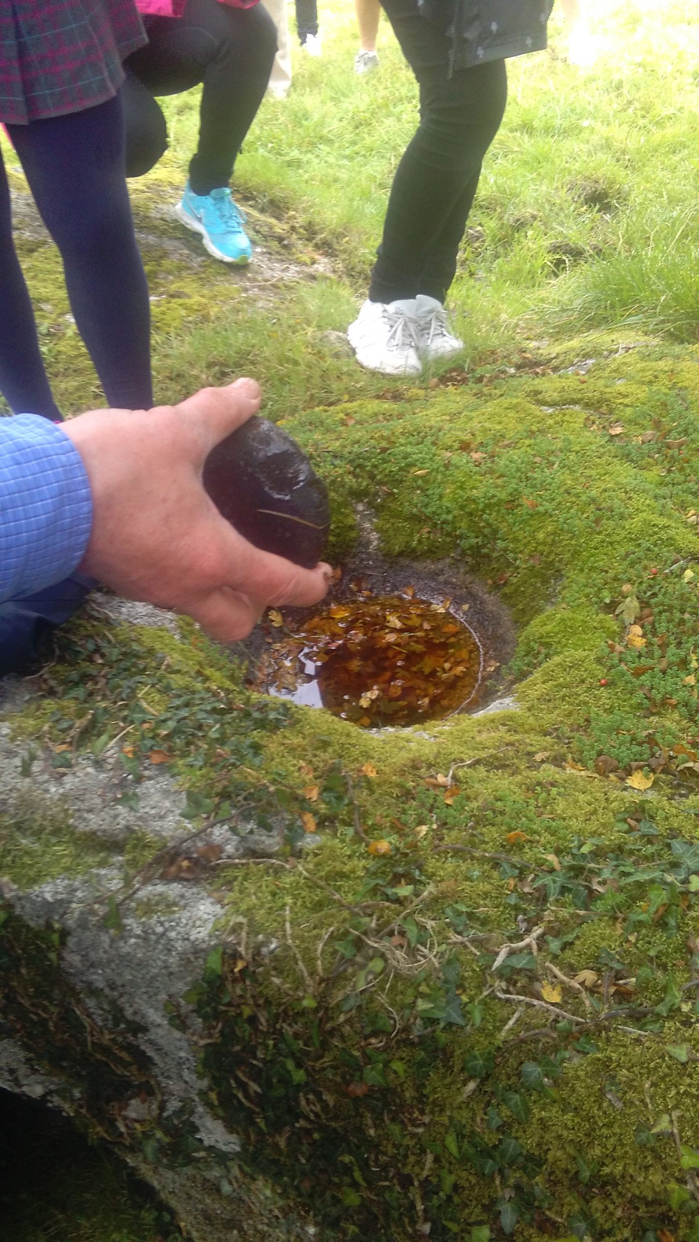
Beside Teampall Einne is a children’s burial ground. Also known as a lisín or cillín this burial ground was no longer used after the 1800s.(9) There is also a holy well Tobar Einne which is one of nine located in Moycullen, a stone leacht (monumental stone heap or altar) and a bullaun. Bullauns were often found near holy wells and both were associated with cures. A bullaun ( bullán) was a hollow in a stone and local folklore beliefs were that the rainwater collected had healing properties. In the past there were visits to Teampall Einne for eye cures on the feast day of St Enda 21st of March. (6)
Dry Stone Walls
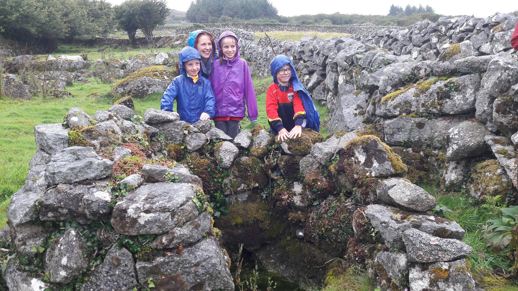
Through generations of tenant farming up until the late 18th /early 19th Century, and afterwards when land came into the ownership of Killagoola people, the dry-stone walls marking out the fields were built. Characteristic of Moycullen and Connemara, they are the skilled handwork and built heritage of the Killagoola farming families. (6) In Killagoola walls are constructed of granite though in other parts of Moycullen limestone is typically used.
Lough Kip River
The Lough Kip (otherwise known as the Killagoola) River passes through the townland on its way to Ballyquirke Lake and forms the boundary between Killagoola and Poulnaclough to the south. Today the river remains a scenic location with daffodils growing on the banks and islands along with hawthorn, blackthorn and holly, and where birds such as chaffinches and the occasional heron are to be seen.
Clydagh Bridge
Clydagh Bridge (while not physically located within the townland boundaries) at the junction of the Galway Clifden Road and the Killagoola Road was an important landmark for those who grew up in Killagoola. In the 1940s and 1950s, this is where friends met each other while Gaelic football and hurling were played in the field across the road. (6) Sports were played at many locations around the parish before there was a pitch at Ballydotia. This is noted in Killagoola man Bartley Faherty’s song, “Ballad of Moycullen” © (4) This was regularly played on radio stations in Boston, where Bartley and many other Moycullen people emigrated:
“To walk by the Killagoola River,
On a beautiful fine Summer’s day
Play hurling and football at Clydagh
Or to swim in Ballyquirke Lake
You can see Tullykyne in the distance
On the shores of the Corrib so clear
Or to sit on the Bridge in the evening
With a friend I held so dear”
Women waited at Clydagh Bridge for Ferguson’s Connemara bus to go to town to sell farm produce at the market at St Nicholas’ church. The butter, eggs and fowl they sold was a source of income for women and the family. Ferguson’s bus was busy and also transported hens and even sometimes a banbh (small pig)! The men of the village crossed the bridge with cartloads of turf, milk, potatoes and vegetables to sell in town. In the 1950s the Bridge was a meeting point before cycling to town to the “Pictures” or to the dance at the Hangar or Seapoint. (6)
Near Clydagh Bridge on the road to Killagoola is the Monument to John Geoghegan. A farmer and member of Moycullen Conradh na Gaeilge and GAA and a district councillor, he died in 1921 during the War of Independence. Rugadh sé i Uguala i Maigh Cuilinn , báile fearthainn atá in aice le Cill Eaguala. Ghlac John páirt sa Cogadh Neamspleachas ó 1919 go dtí 1921 nuair a dúnmharú é. (10)
Wells
The well known as Cruchan Bherla was in use until the 1980s and was noted for its pure spring water. In the past those travelling from Galway City on Ferguson’s bus including Loughwell people, would get off at the Bridge and walk home, stopping at the well for a drink which always had a cup there for the passing traveller. The well went into disuse in the 1980s as piped water arrived in the townland. The well was removed in 2021 due to road widening.
Routes in Killagoola
The townland was heavily populated in the 19th century especially in the middle village and walking the Killagoola road today is still known as “Going around the village.”
Before cars were widespread Killagoola people would cross the Lough Kip River and walk across the bog to Poulnaclogha and the Barna road. Today with less cattle on the land these routes are overgrown with furze.
Field and Place Names
In the past each field, or garraí (garden) as they were called had a name, and these names indicate the use and something of the history of that piece of land and past inhabitants such as the well garden and apple garden seen throughout Moycullen. Killagoola field and place names follow with meaning and location included. (6)
Cnocán Mhor, meaning large hillock. In local dialect Cnocán would be pronounced Cruchan. Cnocán/ Cruchan Garbh, rough hillock. Location Baile Láir/ village of Killagoola. Garraí na Cheártún, Blacksmith’s garden/ field, Baile Láir. Garraí na Scoláire, Scholar’s garden/ field ( a hedge school) Baile Láir. Mountain, is the local name for the heath along the river. Sceith crossroads where there were bonfires and dances. Cruchan Bherla well. Bóithrín Cám, small crooked road. Radharc na Mona, Mountview. Owenloughkip, Lough Kip River. Sruffaunagarra -Sruthán Garbh, which may mean “rough water” and Sruffaunboy -Sruthán Buí, meaning “stream of yellow water”.
- P. Breathnach also recorded the following placenames:
Cnocán na Mionnán and Scailp Dhiarmada at Sráid Tí Mhóir. Poll na hOifige at Lough Kip river. (2)
All recorded archaeological monuments are protected under the National Monuments Acts. Please note access to protected sites is through private property and permission MUST be obtained from landowner noting animals occupy these fields.
References
- Galway Public Library website GalwayLibrary.iePlace names of Galway Galwaylibrary.ie/place/40671 O’Donovan’s field name books: Killagoola
- “Maigh Cuilinn A táisc agus a tuairisc” Dinnseanchas: Cill Eaguala Lth31-32. Pádraic Breathnach Cló Chonamara 1986.
- logainm.ie The Placenames Database of Ireland was created in collaboration with The Placenames Branch (Department of Culture, Heritage and the Gaeltacht)
- Bartley Faherty “The View from Cru Hill” Colm Hayes Press Ennistymon 2009. The song “ Ballad of Moycullen” by Bartley Faherty was recorded and performed by The Andy Healy Band.
- John Reilly, Killagoola, Moycullen Matters magazine interview 1990s
- “Killagoola, a history of a west Galway Townland” C Wall. Walshe Colour Print.
- Clare County Library, Units of Land Measurement.
- “A guide to Lough Corrib’s early monastic sites” Anthony Previte 2010 Old Chapel press.
- “The history of Galway City and County”. Sean Spellissy : The Barony of Moycullen.
- John Geoghegan: Farmer, Conradh na Gaeilge activist, GAA member and Nationalist: Written by Rang a Sé, Scoil Mhuire Moycullen 2014 www.ouririshheritage.org
For sharing their knowledge of local history & traditions and photographs thanks to Tony Lee, Martin Joe Sullivan, Michael Curran, Maura Hynes, Margaret Madden, Margaret Brennan, Kathleen Faherty, Cathy Kenny, Moycullen Weather, Nicholas Clancy, Hazel Morrison Pagett, and Tim Griffin.
Comments about this page
The Galway Express Newspaper of Saturday, 6 August 1910, under an article relating to Galway Rural District Council , stated that “Martin Faherty was declared contractor for 475 perches of the road from Moycullen to Killagoola for 4¾ years at £7.17s”.
I really enjoyed reading this article, well done to all who were involved in producing it, It is great to keep the old memories alive. Hoping for a similar piece on dear old Cloonabinna in the future
Thanks for your comment, Kathleen. We intend to post similar articles on all of Moycullen’s townlands and due to your interest, we will put Clydagh on our priority list.
At least one of ancestors came from nearby Clydagh. Her birth name was Bridget Garvie and she married twice to Peter MacAnealy , a mariner, then Thomas Connor. I saw her 1901 Census return but at the same address in 1911 it was just her daughter Kate Connor (described as deaf and dumb) I’d love to know if there is a similar article as this one written about Clydagh. I am a descendant from her first marriage to Peter MacAnealy.
Add a comment about this page