Moycullen Castle


Moycullen Castle-Birthplace of Roderick O’Flaherty
Moycullen Castle located at Homefarm, Moycullen was the birthplace of renowned seventeenth century historian and scholar Roderick O’Flaherty. This once probable Anglo-Norman site was described by Roderick, himself, as follows:
‘This is my natal soil and patrimony through a long series of ancestors. It was a Manor, exempted by patent from royal tribute, endowed with the privilege of holding a market and fairs, and honoured with the liberty of a seneschal court to settle litigation; but having lost my father before I was two years of age, I came under the tutelary protection of the King by the laws of the country regulating minors, and paid, as was the custom, money for my wardship. But before it was lawful for me by age to enter upon the enjoyment of my patrimonial inheritance, I lost the patronage of my guardian by regicidal execution of my king in the 19th year of my age; and the royal heir, the prince, half a year younger than I, was forced to seek refuge in a foreign clime’.
The executed King referred to was Charles 1 ( d.30th January 1649) and his heir eventually became Charles 11 (1660-1685).
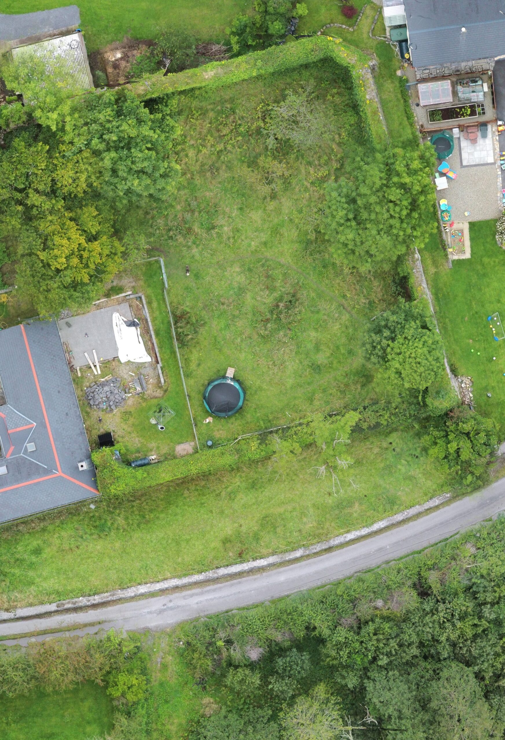
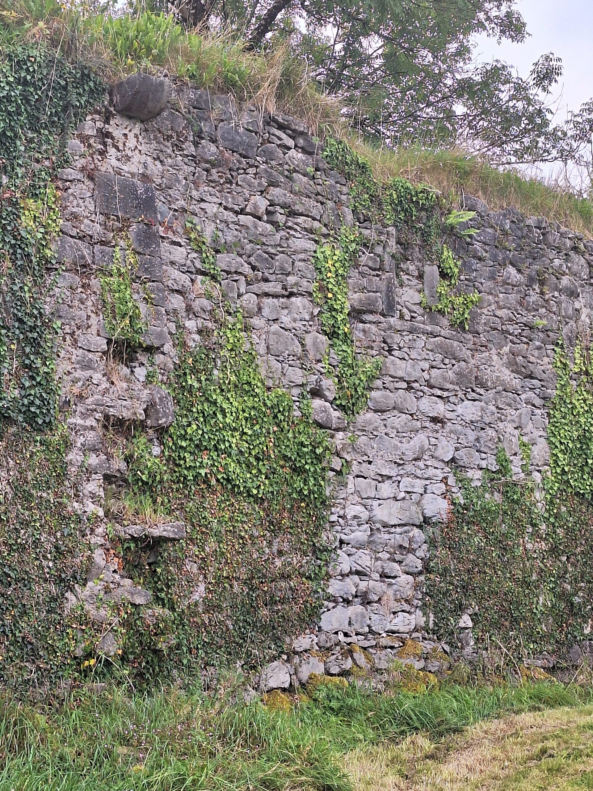
The castle is in ruin
The castle today is a ruin in the townland of Moycullen (Homefarm). According to the record of monuments and places the ruin is classified as a castle. The description is as follows:
‘in an area of undulating pasture to the west of Lough Corrib and around 300 metres West of a mediaeval parish church. In existence in 1574 when it was in the possession of Rory O’Flairte (Nolan 1901, 115). The site is now occupied by Moycullen lodge (Killanin 1947, 122). No visible surface trace survives, but to the east of the lodge is an orchard defined on the north and east by a wide and high wall, possibly a bawn wall associated with the former castle. (Hardiman 1846, 55)’ (Gosling 1993,163).
The OS sheet of 1933 shows a large rectangular double walled garden directly east of the lodge. Both the north and east walls still survive to close to what was probably original height approximately 5 metres while the south wall survives to about one metre high. They are covered with ivy so no features are discernible. The orchard has turned to wilderness making access near impossible. What survives today are two long stretches of wall. The northeast corner has been squared off but most outer facing has been removed. The N wall contains 2 apertures: the western one is very irregular which could be due to fallen masonry. The second located centrally in the wall is lined with red brick and contains a slightly circular segmental arch on top, similar to those found on a tower house. A similar aperture, but with only the roof surviving, is located at the junction of the east and N walls. The east wall has a gaping aperture which has been blocked up. The south wall measures 35 metres long by 1 metre and is covered with ivy.
A Lost Landscape: Anglo Norman settlement West of Lough Corrib
Hugh Gallagher, in his paper ‘A Lost Landscape: Anglo Norman settlement West of Lough Corrib
used cartographic sources to indicate the gradual change of Moycullen castle from a centre for administration and a place of importance. In 1611-12 Englishman John Speed compiled a map of Ireland which showed Morklon Castle but in 1777-78 Skinner and Taylor published a series of maps entitled Maps of the Roads of Ireland. The site of Moycullen castle is shown as a gentleman’s residence inhabited by a Mr French. In 1824 the Ordnance Survey in Ireland was given the job of creating maps of all Ireland at a scale of 6 inches to one mile. Moycullen is marked Moycullen lodge not Moycullen castle. On the 1841 6 inch map two rectangular buildings can be seen within what appears to be the castle but the walls of the latter fortifications are not marked. A large formal garden can be seen occurring to the immediate West of the site of the castle and Moycullen lodge. in the 1890s a 25 inch map series for County Galway were produced. It is clear that the immediate vicinity of the site has been transformed since the 1840s. By 1928 most buildings have been removed and the stone used for other building nearby. Hugh Gallagher’s paper gives one a very good insight into the possibilities of what the castle formation would have been like in its glory days.
The glory days
In Roderick’s time it was the centre of activity. It was the village. It was most likely accessed by Lough Corrib which would have been the obvious thoroughfare into and out of Galway. In recent times the Corrib drainage schemes would have altered the water levels thus making it difficult to envision that this could have been the mode of travel and transport from the castle in the past. His writing of the time gives us an idea of what life must have been like. The castle of Moycullen guarded the best of agricultural land in the whole barony. The O’Flaherty motto ‘fortuna favet fortibus’ suggests that they were more warrior-like than scholarly (Hogan1977) and there was a share of infighting. Roderick was the most learned, but he lived at a difficult time in Irish history with Cromwellian land confiscations having one of the biggest impacts on his life.
Royal references
We don’t know when Roderick was born but in the statement about his early life, he makes it clear that he was born about six months earlier than Charles 11. Charles was born in May 1630 so we can guess that Roderick was born in November or December of 1629. His ancestors he said had been the chiefs of Gnó Beag {sic} for 800 years. He was the son of Hugh O’Flaherty, and his mother was Elizabeth Darcy. Hugh referred to as Roger O’Flaherty was the first of the line to submit to having his title to Moycullen expressed in terms of tenure from Queen Elizabeth.
The Territory of West Connaght or Hiar Connaght’
In his essay ‘The Territory of West Connaght or Hiar Connaght’, written in1683/84, commissioned by William Molyneux for an atlas of Ireland, Roderick described the barony of Moycullin, ‘commonly known in Irish by the names of Gnomore on the north, Gnobeg on the south, is separated on the north from Joyce Country by a ridge of mountains and Lough Orbsen: on the east it lyes by Lough Orbsen and the river of Galway, on the south by the bay of Galway and hath Balynahinsy barony on the west’. Today Lough Orbsen is known as Lough Corrib said to be a corruption of Lough Oirb.
He went on to say that ‘Gnobeg contains the parishes of Moycullen and Rahun……..The castle and mannour, whence the barony and parish of Moycullen are named, hath Lough Lonan on the west; Tolokian, two castles next adjacent, on the north; and Lough Orbsen on the east. The parish church thereon, its chief feast of late is the Immaculate Conception of Our Blessed Lady, on the 8th of December, as patroness. What antient patron it had is not known’.
Today we know Lough Lonan as Ross Lake.
James Hardiman and others
In his footnotes to this essay James Hardiman, who published Roderick’s manuscript in 1846, when referring to Moycullen states ‘This name some have supposed to be derived from Mag Cuillinn, as it is now pronounced, which means the field or plain of the holly; but our author has elsewhere given its true derivation, viz Mag Uillinn, the field of Uilinn, one of the ancient Tuatha De Danann colony’
In 1977 Roderick’s essay accompanied by Hardiman’s extensive footnotes was republished and in his introduction Dr. William J. Hogan describes the book as ‘a treasure trove of knowledge about Galway and its hinterland and it contains a wealth of knowledge about the west of Ireland’.
No Comments
Add a comment about this page